


Earles Voting District, Williamsburg County, South Carolina
About
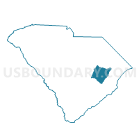
Outline

Summary
| Unique Area Identifier | 666881 |
| Name | Earles Voting District |
| County | Williamsburg County |
| State | South Carolina |
| Area (square miles) | 28.64 |
| Land Area (square miles) | 28.64 |
| Water Area (square miles) | 0.00 |
| % of Land Area | 100.00 |
| % of Water Area | 0.00 |
| Latitude of the Internal Point | 33.42938420 |
| Longtitude of the Internal Point | -79.63530210 |
Maps


Graphs
Select a template below for downloading or customizing gragh for Earles Voting District, Williamsburg County, South Carolina


Neighbors
Neighoring Voting District (by Name) Neighboring Voting District on the Map
- Andrews Voting District, Georgetown County, SC
- Andrews Outside Voting District, Georgetown County, SC
- Cedar Creek Voting District, Georgetown County, SC
- Harmony Voting District, Williamsburg County, SC
- Suttons Voting District, Williamsburg County, SC
- Trio Voting District, Williamsburg County, SC
Top 10 Neighboring County Subdivision (by Population) Neighboring County Subdivision on the Map
- Andrews CCD, Georgetown County, SC (7,608)
- Sampit-North Santee CCD, Georgetown County, SC (3,913)
- Trio CCD, Williamsburg County, SC (2,501)
Top 10 Neighboring Place (by Population) Neighboring Place on the Map
Top 10 Neighboring Unified School District (by Population) Neighboring Unified School District on the Map
Top 10 Neighboring State Legislative District Lower Chamber (by Population) Neighboring State Legislative District Lower Chamber on the Map
Top 10 Neighboring State Legislative District Upper Chamber (by Population) Neighboring State Legislative District Upper Chamber on the Map
Top 10 Neighboring 111th Congressional District (by Population) Neighboring 111th Congressional District on the Map
Top 10 Neighboring Census Tract (by Population) Neighboring Census Tract on the Map
- Census Tract 9202.01, Georgetown County, SC (5,283)
- Census Tract 9208, Georgetown County, SC (3,913)
- Census Tract 9709, Williamsburg County, SC (2,501)